
The Great Lakes Nation
What’s the sitch with the value of freshwater?
As someone raised in the Midwest, I’m used to having large bodies of freshwater a stone’s throw away. In fact, that is what we often do with our freshwater around here. Minnesota is the land of 10,000 lakes (actually closer to 11,842), and also contains the headwaters of the Mississippi. One state to the east, in Wisconsin, they have so much freshwater that they have turned most of it into beer to prevent flooding. Michigan, one state further east, has the longest freshwater coastline of any political subdivision in the world, it being two peninsulas bound by four of the five Great Lakes. I could continue to name Midwestern states and their freshwater fun facts, but the point is, in my experience, it has been easy to take fresh, clean water for granted during my time drinking it. This also means I haven’t been forced to grapple with the hard questions; to dock the pontoon boat, put away the pool noodles, and ask, what is water? Why do we need it? And what is its true value?
Water is that stuff that falls out of the sky as little drops, on occasion. What you may not know, is that it’s also that stuff that you mix with corn syrup, caffeine and yellow 5 to make Mountain Dew. Amazingly, it is also the stuff that’s essential for all life to exist on Earth. Which is why many are concerned that, as a global population, our water consumption is rising much faster than the corresponding increase in water access and distribution.
The fact that water is necessary seems self-evident. And it would follow that, a shortage of water is obviously bad. But when using, “Five Why’s Analysis,” (recently taught to me by a water-loving friend), the supposed clarity of this problem is quickly muddied:
“I get thirsty almost everyday, so without water I would always be thirsty, and being thirsty sucks, so water is good.”
Not a bad point. But why do you get thirsty?
“Well, receptors in my brain sense when my blood has an increased solute to water ratio, and respond by causing me to feel thirst, as well as by signaling my kidneys to hold onto more free water.”
Wow, you seem to be pretty well-informed. But, again, why does your body have these mechanisms in place?
“Well, I need to perfuse my tissues with blood, and keep my brain bathed in cerebrospinal fluid, and lubricate my joints, and secrete digestive juices into my gut, etc.”
Right, right… but, why?
“Dude! You’re acting like a child! I mean, I guess… I guess because the polarity of H2O molecules allow water to remain in a liquid state at many Earth-like temperatures? And this polarity also provides the subtle forces necessary to dissolve most solutes? And these two properties in tandem provide an environment for maintaining diffusion gradients across semi-permeable membranes (the structure of which also rely on water’s polarity), which are required for all essential life processes, such as utilizing the energy from the bonds of a glucose molecule, concentrating waste products for excretion, or transmitting impulses along a neural circuit… etc? Any more fucking whys?”
Actually that’s pretty good… I feel like we are closer to an understanding of why a water shortage may be a real problem. But, to be fair to the process, we really do need a 5th why.
“I’m exhausted… and I’m not sure there’s any more to explain. We could get into chemically why water molecules have their intrinsic polar qualities, but I doubt that will be of any value. I suppose the answer to the fifth why is because God loves water, and therefore bestowed the greatest amount of water upon those places he or she likes best.”
Bingo.
But what God may not have thought about when hastily allocating water resources approx. 6,000 years ago was that, humans can use freshwater much more easily than seawater. (And, of course, it seems God didn’t consider that humans move around, conquering and subjugating one another regularly, stealing each other’s lands and resources in the process. So God really should have made us non-violent and non-covetous if he or she was serious about the favorites actually holding onto their holy endowed waters.)
Seawater is more than three times saltier than our blood, and is much more concentrated than the most concentrated solution human kidneys can produce. Functionally, this means ingesting seawater will actually pull water from our bodies in order to dilute and excrete the extra salt load. When it comes to hydration, sipping from the Pacific Ocean is closer to munching a bag of Doritos than it is to gulping a cool glass of filtered tap water.
Unfortunately, though 75% of the Earth’s surface is covered by water, 97.5% of the water is saline. Of the 2.5% leftover, 70% of that is frozen in glaciers and permafrost. Squishing thoseinto one meaningful number, about 3/4ths of 1% of Earth’s water is readily available for human consumption and agriculture. (Oh, and that’s all the water that is available for the other plants and animals that rely on freshwater as well… the “non-humans” as they are known.)
Even with that small fraction in mind, we’re not in danger of truly “running out” of freshwater on a global scale; that’s not really an accurate way to think about the current problem. It is more useful to look at, “regional stocks and flows of water and the impact of human appropriations.” (1) By some estimates, humans already exploit more than half of all renewable freshwater flows, including for “dilution of waste,” (aka dumping our shit in the river). We also incorporate huge stores of water into products and crops that we then ship to other parts of the world. Large amounts of rain water and soil moisture are redirected by cultivating and developing land. Great quantities are warmed and evaporated when cooling power plant cores and industrial engines.
Much of the water we use is “renewable,” in that it will be replenished relatively quickly by natural processes. But, on a regional level, when growing demand outstrips active supply, it doesn’t really matter if the water still “exists,” somewhere or if it will return the following year; that water isn’t available to wet the golf course right now. Additionally, many water sources that were once “renewable,” may no longer qualify, including rivers fed by glaciers that are shrinking, lakes topped-off by rains that have moved with changing weather patterns, or underground aquifers that took thousands of years to slowly fill, but which are now being drained over the course of a few decades. (Google Ogallala Aquifer for more on this!)
A high profile example of a “renewable,” water resource we are testing the limits of in the U.S. is the Colorado River. Water from this river and its tributaries supply most of what is used by the seven states downstream in its basin, encompassing all of the Southwest and Southern California. A compact was made in 1922 among these states, as well as with Mexico, splitting up annual allotments of the river’s flow to each. Unfortunately, and sort of predictably, the allocations agreed upon at the time were based on years of above average precipitation,overestimating the amount of yearly water through the basin by up to 15%. And, of course, the cities and agricultural production in the area have changed in the past 90 years a little bit.
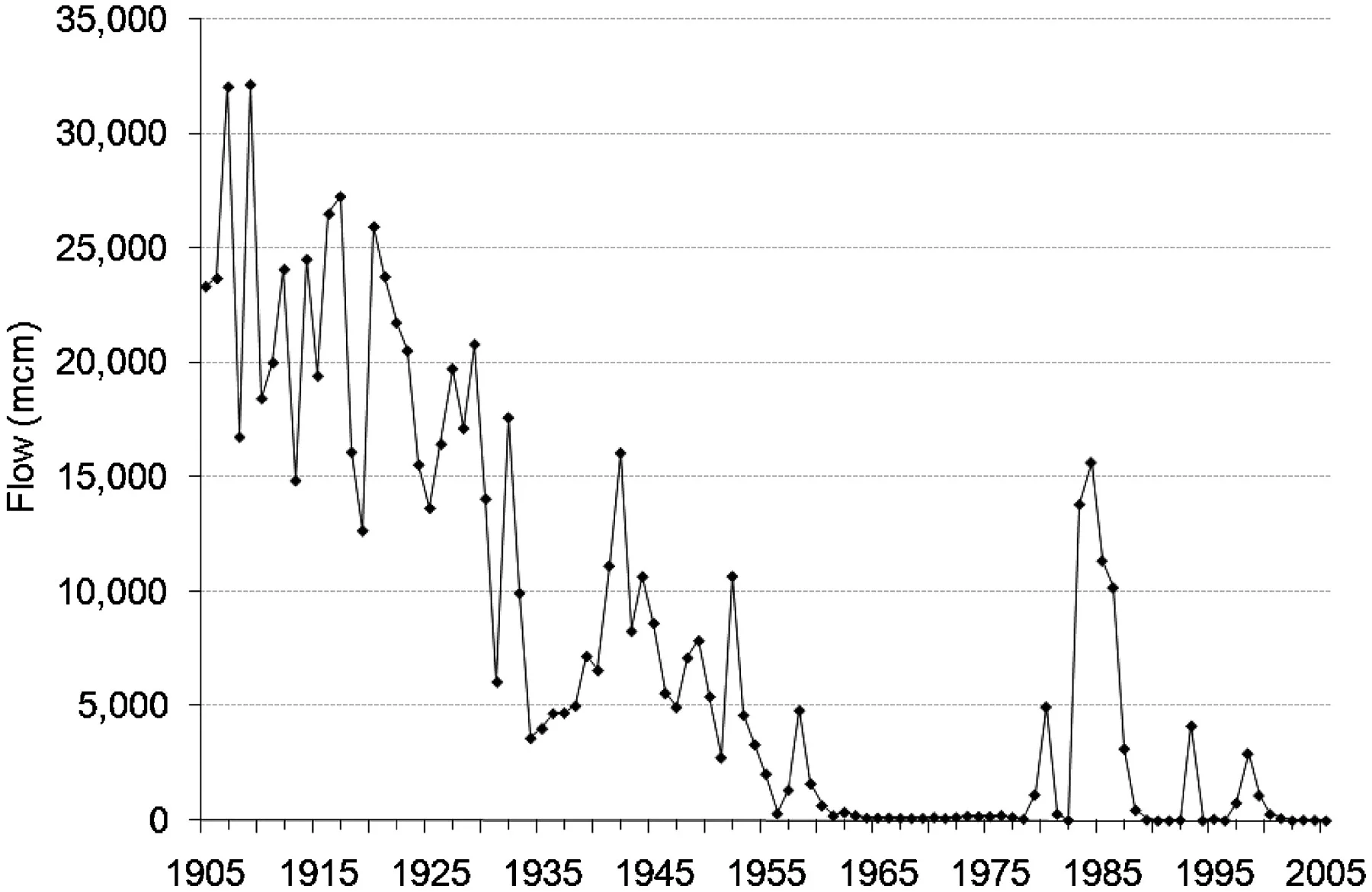
“Annual flows (in millions of cubic meters) of the Colorado River into the delta from 1905 to 2005 at the Southern International Border station. Note that, in most years after 1960, flows to the delta fell to zero as total withdrawals equaled total (or peak) renewable supply. The exceptions are extremely high-flow years when runoff exceeded demands and the ability to store additional water.” (1)
California, as the most populous and agriculturally productive of the states negotiating the initial compact, was given the largest allotment. They are also geographically the farthest downstream, and so have access to surplus water left over from other states. As you can see in the chart above, with the exception of a few years, no water has reach the Colorado River Delta since the 1960s; every drop of this “renewable,” freshwater is used or retained in reservoirs annually.
And I suppose this would be alright if we were sure that the weather was going to cooperate, and continue to shower exactly as much rain every year as it had in the past, which we’ve seen recently is not something to be relied upon.
(Also, of course, conceding that using an entire river’s water each year, “would be alright,” is only the human perspective; all of the wildlife and wetlands in the Colorado River Delta were dead and dried a long time ago. Perhaps some Sandhill Cranes should have written an article about how thirsty they were down there… but even evidence that Cranes have learned to use QWERTY keyboards is unlikely to stop the American public from buying California strawberries in January. [Also, to be completely fair, in the spring of 2014 a multinational agreement was made to release a pulse of water from the Hoover Dam and allow it to travel all the way to the delta, briefly rejuvenating the area and restoring some stocks of ground water. The amount released, that one time, was less than 1% of what would naturally be flowing into the delta annually. There are on-going talks about having these small “pulses,” become a regular thing.])
Some multinational corporations have been watching these regional water shortages closely, saliva dripping from well-moistened palates as the angles of their mouths curl skyward. Switzerland-based Nestlé bottles more water than any other organization in the world (and is also the largest food company in the world, by revenue). They have come under fire recently for buying up large swathes of land sitting on aquifers, thereby granting them rights to pump and bottle the underlying waters. The company has done this in the United States, leading to protests and lawsuits against them, but never substantially contributing to a true water shortage, rather, just contributing to the perception that they are assholes. But Nestlé has also purchased land in more unstable regions, like Pakistan and Nigeria. In those places, where water resources and the infrastructure for home delivery are less developed, any decrease in groundwater level can have far-reaching effects on the average citizen’s access to hydration. Of course, Nestlé is motivated to dry these places out, so the only alternative to Nestlé’s “Pure Life” bottled water is a weak, muddied stream from the village fountain. It truly is the evil plan of a super villain unfolding in real time, and it seems to be working.
(The company went so far as to lobby the World Water Council to change the language in a statement, so that instead of access to drinking water being a human “right” it would only be a “need.” Wowza. I thought Nestlé was just a family of happy Swiss folk making chocolate in the Alps, but they really are the worst. For more on this story, see, “Bottled Life,” a recent documentary film by Urs Schnell and Res Gehriger.)
We’ve established that real regional water shortages are underway, in both developed and developing nations, and that there are already capitalists involved, preying on the weak while monetizing the growing gap between supply and demand. (For a good image of where water shortages are happening globally, see: https://d267cvn3rvuq91.cloudfront.net/i/images/desalinationx950.jpg?sw=790 [2].)
When an area finds itself consuming all available water resources each year, there are a few options to meet additional needs.
Reducing demand for water, by making irrigation more efficient, fixing leaks in the delivery systems, reducing toilet volume, educating the populous on water conservation, etc.
Move water demand to another region where additional water is readily available by, say, moving the soda factory from Dubai to Maine (still supplying the people of Dubai with soda, but shipping in the water resources as an already formed, water-containing product).
Or, usually as a last resort, invest in a higher priced supply of water, drilling deeper to find new aquifers, transporting water in from regions with plenty, or by desalinating ocean water.
In the developed world, and the United States specifically, there is still room for making our delivery infrastructure more efficient and recycling more. But in some places we will reach the limits of this option for solving regional water crises. As California, Texas, and the Southwest get squeezed, they will eventually find that they can’t conserve what they don’t have.
Moving water-hungry industries to regions with greater natural stores will likely occur as scarcity spirals, but this will be limited to products that don’t rely on the other natural resources of the Colorado River Basin, such as powerful sunshine, long growing seasons, arable land, experienced human capital, oil reserves, etc. Perhaps some Arizona golf courseswill shutter their doors (?), and that lone Las Vegas factory making pre-filled water balloons would be wise to take their operation east. But many industries that thrive in the Southwest, such as agriculture, livestock and energy production, cannot move if they want to still produce at the rates they are accustomed to.
It is inevitable that regions with water shortages in the U.S. will have to invest in higher priced supplies of H2O, at least as an adjunct to better source management, maximized delivery efficiency and improved use-reduction incentives.
The process of desalination has been implemented extensively by dry, coastal countries such as Israel, Australia, and Saudi Arabia for years. Texas and California have more recently invested in large-scale desalination efforts, both to freshen brackish groundwater and to make actual seawater drinkable. It is increasingly becoming a final, expensive option for drought-stricken communities. San Diego County recently opened the largest seawater desalination plant in the Western Hemisphere for ~$1 billion, which will soon provide an estimated 10% of the county’s water needs. (2) (And again, see the link a few paragraphs up for a good chart on the growth of desalination projects around the world.)
As of 2016, it costs approximately twice as much for a gallon of desalinated water as it does for a gallon of water obtained from building a new reservoir or from recycling wastewater. The price is up to four times more expensive than funding new conservation methods, such as incentivizing lawn reduction or installing efficient toilets. More than 2/3rds of the cost of desalination is due to the energy required to force water through specialized membranes that separate salts from water, in a process called reverse osmosis. Energy costs are notoriously volatile, and while they have been relatively low recently, there is very little doubt that they will generally increase over the course of the next 20, 80, or 200 years (barring the development of a thermonuclear fusion reactor). Which will directly impact how much a glass of water costs.
The technology of reverse osmosis hasn’t changed much since the 1980s, though desalination plants’ modern computerized efficiencies and upstream energy reduction have dropped costs somewhat. There are a variety of efforts, including by the nerds at MIT, to improve the desalination mechanism altogether, using membranes that are only atoms thick, or by using electrodialysis. But these new filtration theories have not yet been shown to work on a lab bench, let alone on the massive scales required to provide water for a city. Additionally, some in the industry believe the thermodynamic limits of salt extraction are close to being reached with the best of our current technology. Even when giving credit to the ingenuity of humans, it is highly unlikely that a gallon of desalinated water will cost the same amount as a gallon of naturally fresh water until some sort of environmental/nuclear/astrological catastrophe pollutes all global stocks of surface water, forcing us underground to lick the few remaining droplets from stalactites, pale and wide-eyed contusions of our former crust-dwelling selves. (At that point you are allowed to disregard the analysis that follows in this current sitch.)
Additionally, desalinated water is not a great option for many water-stressed regions that are poor, deep in the interior of a continent, or at high elevation. “One needs to lift the water by 2,000 m (6,600 ft), or transport it over more than 1,600 km (990 mi) to get transport costs equal to the desalination costs,” (3). Costs will be astronomical if water needs to be both desalinated and transported to a nearby mountainous, landlocked region. So transporting freshwater will perhaps be economically more feasible for many places.
Due to increasing demand and changing regional supply, natural fresh water has started to steadily rise in value, as pressed communities seek expensive alternative sources for that sweet, sweet liquid.
“Now it is my turn to ask… why? Why have you led us through this semi-informative, often-tedious clarification of the apparent freshwater crisis that we have all pretty much heard of, and which could easily have been summarized in like, a paragraph or two? Isn’t the title of this website ‘What’s The Sitch?’ I wish the content was as abbreviated…”
At this juncture, it is worth mentioning that the Great Lakes of North America hold 21% of the world’s surface freshwater by volume. I’ll rattle off a few more impressive stats about the quantity of water they hold, because it’s the most fun I get to have in my day. Lakes Superior, Michigan, Ontario, Eerie and Huron make up 84% of the surface freshwater in North America. Their surface area combined is roughly equivalent to the United Kingdom. If their waters were evenly distributed, the entire continent of North America could be covered in 5 feet of water, or instead, we could choose to cover the just lower 48 states in 10 feet of water… either would be fun. Only 1% of the Great Lakes’ water is “new” each year (originating from rivers, precipitation and groundwater springs) and historically this has been balanced with evaporation and drainage, making the levels of the lakes relatively constant through time.
Furthermore, if all the Great Lakes’ water was canned into Tallboys (16 oz beer cans) and stacked end-to-end in a great swaying spire of aluminum, they would reach the ice giant Pluto at the furthest point in its orbit… 1000 times over. You read that correctly; instead of Great Lakes, we could have five Great Lake-sized holes in the ground, along with 1,000 spears made of Tallboys connecting our planet to Pluto. Something to think about NASA. Additionally, based on the average American shower rate of about 2.1 gallons per minute (www.home-water-works.org), even if rain stopped falling from the sky one day, I could hook my plumbing intake up to the Great Lakes and continue to shower… for the next one million years (4). Though I bet the hot water wouldn’t last that long.
The history of the Great Lakes is storied, diverse, and as epic as their vast waters, which is why I’ll save the majority of it for another time. Their origin is somewhat disputed, as many posit they were formed when the God gave water to those he/she favors most (as mentioned before). Others (with a decidedly liberal agenda) claim the Great Lakes were created when glacial ice sheets retreated 14,000 years ago, carving massive hollows and filling them with meltwater. No matter which camp you are in, let’s fast-forward to 1783, when, after a victory in the Revolutionary War and the subsequent Treaty of Paris, the newly minted United States claimed the territory west of the original 13 colonies. In 1787, the Confederation Congress created the Northwest Territory, bound by the British North America (aka Canada) and the Great Lakes to the north, the Ohio River to the south, and the Mississippi River to the west. Though Massachusetts, Connecticut, New York and Virginia all had overlapping land claims in the area from colonial times, Thomas Jefferson proposed the lands should be taken by the Federal government and divided into new states that would join the Union. (He also proposed the creation of 17 roughly rectangular states from the territory, and suggested naming them Chersonesus, Sylvania, Assenisipia, Metropotamia, Polypotamia, Pelisipia, Saratoga, Washington, Michigania and Illinoia… while revered as a Founding Father, author of the Declaration of Independence, philosopher, political innovator, and renaissance man, he never did receive enough credit for his ability to come up with cool names.)
Following this act, the Great Lakes were officially (partially) United State’s property. Which kicked ass. But to really make them as “Great” as they are today, someone needed to step up and connect them to the Atlantic Ocean, facilitating transport between the Eastern seaboard and the then western edge of the country. Construction on the Eerie Canal began in 1817, and was completed in 1825. This engineering marvel spans the 363 miles from Albany, NY, on the Hudson River, to Buffalo, NY, on Lake Eerie (and is widely considered the reason these cities became what they are today). At the time of its completion, the canal was thought to be prettysweet, as it cut transportation costs along its path by 95%, and encouraged the flux of settlers heading west. It was second only to the Grand Canal in China in terms of longest artificial waterway, and to this day the Eerie Canal is the fifth longest canal in the world (with the other three long ones being built in Soviet Russia… typical). (In 1959 the St. Lawrence Seaway officially opened, which was a much deeper collection of canals along the St. Lawrence River running northeast from Lake Ontario, allowing modern, large, deep-draft ocean liners access to the Great Lakes from the Atlantic Ocean at the Gulf of St. Lawrence in southeastern Canada.)
Many of the Irish immigrants who helped in the construction of the Eerie Canal then worked on the Illinois and Michigan Canal, which was completed in 1848. This connected Lake Michigan to the Mississippi River, linking the Great Lakes to the Gulf of Mexico and fully establishing the them as a hub for shipping and trade in the adolescent country. This canal was also directly responsible for making Midwestern farming profitable (as agricultural goods could actually be shipped to more populous areas) and for stimulating Chicago into the booming center that it still is today.
But I digress. The Great Lakes are giant tanks of freshwater in the middle of two stable nations, connected to the outside world by a couple of large waterways. These features helped in building the Megalopolis that now surrounds the lakes in 2016. This term was coined by geographer Jean Gottmann in 1961, and was meant to describe the concept that modern cities are better studied as, “participants in urban networks revolving in widening orbits,” rather than viewed in isolation. A 2005 report by the Metropolitan Institute at Virginia Tech used this idea to reassess America’s Megapolitan Areas in the present day. Their (abbreviated) definition of these areas is as follows: an area that include at least two “metropolitan” areas, has more than 10,000,000 projected residents by 2040, constitutes an “organic” cultural region with a distinct history and identity, and represents a usable geography for large-scale regional planning, with links between large centers through major transportation infrastructure, thus forming a functional urban network via goods and service flows. (5)
These geographers have a much more nuanced understanding of the Megalopolis concept and its importance in planning the future of America’s cities… but I think we pretty much get it. Traditional cities, with familiar names, are growing together, via sprawling concrete, expanding transportation routes, and increasing connectivity. Hubs are connecting to one another, and these urban hubs are fed by surrounding resources and agriculture. We can begin to describe large regional conglomerations for what they are, rather than continuing to say, “Yeah, it is strange that you work in Washington D.C. but actually live closer to Baltimore; they are two completely different cities!”
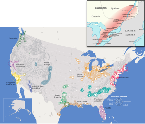
In their paper, the VT Metropolitan Institute describes ten current U.S. Megapolitan Areas. Below is a map of a slightly different, but largely overlapping interpretation of the currentU.S. Megalopoli, as well as a map of the Quebec City-Windsor Corridor, a densely populated and industrialized region of Canada adjacent to the Lakes in the north.
Being relatively liberal with the boundaries of this Great Lakes mega-region, the area includes, in order of population: Chicago, Toronto, Detroit, Montreal, Minneapolis-St. Paul, Cleveland-Akron, St. Louis, Pittsburgh, Cincinnati, Columbus, Kansas City, Indianapolis, Milwaukee, Louisville, Ottawa, Grand Rapids (MI), Rochester (NY), Dayton, Buffalo, Quebec City, Madison… and five other cities with greater than 500,000 people.
The estimated population of this region is ~60 million peeps, most of them well-intentioned Midwesterners (or really cool transplants we are slowly turning into Midwesterners). According to the Brookings Institution, if the area stood alone as an economic unit, it would have an estimated $4.5-trillion gross regional product per year, a figure that would put it behind only the rest of the combined United States, the European Union and China in terms of total cash-money-making. It would be pretty much tied with Japan. And if the rest of the US was chunked into the other above megaregions, the Great Lakes would be both the most populous and have the greatest economic output. (Yes, yes, I crunched the numbers… the Northeast has about 50 million people and a $3.6 trillion GRP, California/Nevada combined have ~43 million people and a $2.6 trillion GRP… the other regions aren’t close.)
The strength of this region has been well-documented since the late 19th and early 20th century, when iron from northern Minnesota and Wisconsin met with coal from the mines of Appalachia to create the Steel Belt along the eastern shores of the Great Lakes. This gave way to the Factory Belt during the midcentury, comprised of the great American manufacturing cities. Unfortunately for some, the automation of many industrial processes along with the expansion of worldwide free trade pushed the region into decline in the 1980s, when the term “Rust Belt,” entered common parlance.

“Change in total number of manufacturing jobs in metropolitan areas, 1954–2002. The national average over this period was -8.65%. Green=greater than 60% growth in manufacturing jobs; Light green=54.4% growth to 7.5% decrease; Yellow=8.7% to 29.1% decrease; Pink=31.2% to 43.2% decrease; Red=43.6% to 56.2% decrease; Maroon=58% to 88.6% decrease."
While population loss, high unemployment, and depletion of local tax revenues has persisted to some extent in places like Detroit, Cleveland, and Buffalo, many cities in the region are in the midst of transforming themselves to face the 21st century. The infrastructure is in place to accommodate more people and industry, it is now just a matter of attracting talent and investment.

As opposed to industry in the east, agriculture has long dominated the region to the west. These states form the so-called “Corn Belt,” and a little bit further into the plains, the “Breadbasket of America.” The United States produces 40% of the world’s maize crop, most of which comes from the green areas you see on the map to the right. The majority of that corn is then fed to livestock. As we often say here in the office, “Dang, that’s some crispy bacon.”
In order to expand the region’s economic interests and protect the lakes that guide its form, the Council of Great Lakes Governors was created in 1983 between the Governors of Illinois, Indiana, Michigan, Minnesota, Ohio and Wisconsin. The Governors of New York and Pennsylvania joined in 1989, and the Premiers of Ontario and Quebec were included more recently (which necessitated a sweet title change to the Conference of Great Lakes and St. Lawrence Governors and Premiers). In 1985, these leaders made a good-faith agreement called the Great Lakes Charter, outlining principles to collectively manage the use of the Great Lake’s Basin water. This charter also established an explicit consultation and agreement process for any proposals to divert large amounts of water out of the region. Building on this previous handshake deal, the council signed a legally binding version, called the Great Lakes-St. Lawrence River Basin Water Resources Compact, in 2008. (Whenever I don’t include citations for facts, it’s either because I’m making them up as I go, or I’m getting them from Wikipedia, which I assume you all know how to use.)
“Sigh… I really should never have engaged on this topic. I’ve learned a little bit about a lot of things, none of which I care about at all. I’m getting the sense that this will all tie together, but I’m not convinced you and your staff know wtf you’re doing. You seem to ramble until you run out of steam, and then call it an essay.”
I thank you for your patience anonymous dissenter. Some might find the final portion of this sitch radical, and I wanted to set myself up for success. So I laid out some facts first, despite their dreary qualities.
The Great Lakes region of the United States and Canada, no matter how you define its boundaries, is one of the great economic engines in the world. A decline in its industrial sector in the past half-century has likely only primed it for future growth and renewal. With a vast fringe of rich soil, the area has a long track record of harvesting grain and livestock. Connected to the oceans by large, patent waterways, yet protected from coastal dangers such as rising tides, violent storms, or even invading enemy forces, it is a safe haven in a world of reverberating unrest. Lastly, and with an eye to the future, this region surrounds the largest group of freshwater lakes on Earth, a resource that will only increase in value during years to come.
The Conference of Great Lakes and St. Lawrence Governors and Premiers, as well as the people in the states they represent, have a few options for the future:
A) Starting with the “smart,” “ecofriendly,” “morally responsible,” move, the Conference of the Great Lakes Governors and Premiers could expand their powers and then focus on preserving every drop of the precious natural water resources. Large investments in region-wide infrastructure, including improved water transportation efficiency, state-of-the-art treatment facilities, and wetland restoration, would ensure access to freshwater for countless generations to come. Additionally, the governors and premiers could push for broad legislation subsidizing water use by industry and agriculture, providing cheap water for those using it to stimulate the regional economy. Every modern product requires way more water than you’d think to produce. One cup of coffee, from seed to Starbucks? 140 liters of water. One liter of milk? 800 liters. Textiles require a ridiculous amount, as does manufacturing, mining and fuel extraction. Even large banks have a bunch of water coolers in their office buildings. As the cost of water rises in relation to the cost of labor and space and steel and gumption, having cheap water at the ready gives a distinct economic advantage to any process requiring it; which happens to be all processes. Sooner than we know, it will be far cheaper for industries to thrive in the gullies of Chicago or the suburbs of Minneapolis than elsewhere in the country, let alone in the Southwest.
As companies flock to this new and improved freshwater haven, unemployment will plummet, tax revenue will swell, and reinvestment in the already rock-solid freshwater annuity will follow. The Great Lakes Megalopolis would become a top destination for talented individuals from around the world. Those already owning property in say, Milwaukee or Buffalo would see their investment skyrocket in value, and established Midwesterners would benefit most, even as others joined in the prosperity emanating from the Lakes. This is alongterm plan, the dividends of which may not be realized for decades or even a century… which also makes it the most boring option.
B) Secede from the Union (and from Canada), forming a new sovereign nation based around the power of the Great Lakes. This would require the Conference of the Great Lakes and St. Lawrence Governors and Premiers to meet in secretive north woods cabins for a number of years, sipping PBR or Labatt Blue while hammering out details and logistics.
It would be a peaceful secession, set up quietly and then declared on one historic day. Any day other than July 4th would do. The secession would be based not on xenophobia or racism (as many historical and more recent secessions have been), but rather on sequestering a precious resource for a smaller group dedicated to managing it properly. Immigration would still be welcome into and out of the new nation, as long as the people coming in were willing to respect the sanctity of the freshwater above all else.
The new federal government of the Great Lakes Nation (GLN), still following much of the old Constitution of the U.S., would not be located among the stuffy suits in Washington D.C., but perhaps in blue collar Detroit, or even in mild-mannered Toronto. Simply by the act of relocation the goals and intentions of the nation would be focused. With economic security ensured by vast stores of protected freshwater, the new nation could focus on the health and wellbeing of all its people, and on continuing to preserve the environment which helped grant its independence.
The exact organization and inclusions in the new nation could be debated for years. To give the bold defection the best chance to be successful, the governors of New York and Pennsylvania would have to be charismatic enough to convince their entire states to get on board; continued access to the Atlantic Ocean would be essential, and Philadelphia’s and NYC’s participation would make the fledgling Great Lakes Nation that much stronger politically and financially. We are also assuming the entire province of Quebec is amenable to secession, as the St. Lawrence Seaway is another critical piece to the puzzle (but those French-Canadians have wanted independence for a long time). Other cities/states could be discussed, depending on the assets they bring to the table:
St. Louis? Perhaps. Though it is pretty far south from the Lakes, it is an important metropolitan area on the Mississippi. With the incorporation of this gateway city, the GLN would have a stronger hold on the mighty river; the threat of damming it to contain its vast waters north of the border would be a strong bargaining chip.
The rest of the Northeast? With New York and Pennsylvania willing and able, Massachusetts and the others would be cut off from the remains of the United States, giving the GLN an upper hand in negotiations. Their admittance would give our young citizens more options for college without having to go abroad, and would do much to ensure the loyalty of established East-coasters living in NYC and Philadelphia. It would be important for the seat of the new federal government to be in a central city with a true stake in the preservation of the Great Lakes’ waters, and not on the Atlantic coast; while much of the eastern seaboard may be involved by the time the dust settles, they are not as important to the stability of the GLN as any of the states with a border on the Lakes.
By now you may be thinking:
“This is a very stupid proposition. Why secede from the most powerful nation on Earth? Why separate from the rolling hills of the southeast, the epic crags of the Rocky Mountains, the oil fields of Texas, the multicultural mecca of New Orleans, the golden coast of California, the tech rainforests of the Pacific Northwest, etc?”
If this disunion were about the assets being left out of the new nation, it would make very little sense indeed. This theoretical split is not about challenging the beauty of the rest of the lands making up the United States. And it certainly is not about claiming the people of the GLN are superior in anyway to the peoples of the other great regions across our current union. It is a disaffiliation for the purpose of focusing; legislatively, economically, and spiritually, on what is most important to the preservation of the GLN region and its peoples. It is not so much a rift, but a sequestration. A sequestration of exquisite grand pools of potable water.
The winds of change are coming, whether the GLN is formed or not. I know many of you may not be paying attention to the 2016 presidential election, as it hasn’t been getting the press coverage generally afforded to important events (that’s called sarcasm in the industry). But many people, across the nation, across the world, are confused, scared, and uncertain of the best course of action to ensure the safety and prosperity of themselves and their loved ones. The mechanisms of large-scale decision making currently in place don’t seem to be as effective as they once were.
The GLN that our staff of writers is imagining would be a more agile, concentrated version of the current land-of-the-free we live in, with a large cache of the most valuable resource of the future. This secession is more akin to cradling the biggest piece when a delicate vase shatters than it is to wielding the bat that did the deed.
We would expect other regions to glom together as well, forming other small nations from the remains. But the GLN would have a game plan, and a starting lineup in place, while the others would be scrambling to field a team. And it goes without saying, ours would be the best hydrated.
Yes, other questions remain:
“When?”
When the getting is good. We should start in 2016 by hiring a tight-lipped economist who is an expert on water resources. If we can predict when freshwater will peak in price, but not be so valuable as to warrant true violence over its ownership… that is when secession would be possible. We need the assurance of financial dominance to convince the peoples of the states bordering the Lakes, while still holding onto the crucial element of surprise.
“And what if there is violence?”
That is a true risk. We would need a charismatic leader to negotiate a peaceful departure from the U.S. of A. If the old federal government decided to invade in order to retain the Great Lakes and the surrounding states, it would be next to impossible for the GLN to emerge victorious. But that action from the Feds would reinforce our cause. Yes, the secession may fail. But as likely, the volunteer soldiers would not murder their fellowman over a desire to be free from a failing state, over a desire to control the destiny of their local resources. Timing would be everything in this secession, when the country is at the brink of dissolution, but prior to actual event. The secession of the Great Lakes Nation would be the initial action during the fall of the United States.
C) Our last option would involve dissolving the Conference of the Great Lakes and St. Lawrence Governors and Premiers and all of their past agreements, followed by building pipelines to pump water to states that need it, for a slightly cheaper price than it would cost them to obtain the water by other means. We would be the drinking fountain of the nation, while the Great Lakes lasted. This would probably be sustainable for a very long time, but not forever. The region could get rich, and be rich, for a long time, but not forever. And it is just as likely that a select few people and corporations would retain the majority of the wealth, as is the case when other natural resources are exploited. Not a terrible option, and I suppose we could always try to stop piping it elsewhere once the stores got frighteningly low… Unfortunately, this is at least as likely as the other two options, given how shortsighted and greedy humans are.
We here at whatsthesitch.com don’t truly believe any of the above proposals will be relevant for many, many years, if ever. But radical ideas take time to marinate in order for their flavors to develop; large-scale political movements take patience to see through. This sitch is meant to serve as a jumping-off point for a future we hope never arrives. We all love our country, every nook and cranny, every valley, every peak, every dry patch, every rainy culvert, every man, woman and child. But, if freshwater does continue to elude large swathes of the nation, and if our federal government fails to adequately represent significant chunks of the populous, splintering off with the Great Lakes in-hand may be necessary. And the staff here at whatsthesitch.com want lakefront property and a spot in the new administration.
*sitch brainstormed with the ever-inspiring MM
Wormhole discoveries worth checking out for yourself:
>Lake Baikal (https://en.wikipedia.org/wiki/Lake_Baikal) is the world’s oldest lake, and the lake with the most freshwater by volume, containing a little more than all of the North American Great Lakes combined. It is in Siberia, just north from the border of Mongolia. Nicknamed “the Pearl of Siberia,” it’s huge, clear, and seems pretty cool.
>The Aral Sea (https://en.wikipedia.org/wiki/Aral_Sea) was once the fourth largest lake in the world before the Soviets diverted all the rivers draining into it in the 1960s to grow cotton. The “sea” is now less than 10% of its original size and is still shrinking. The Kazakhstani/Uzbekistani populations living in the area were all but destroyed as their lake-based livelihoods were taken from them. The receding sea also left a desert prone to violent dust storms in its wake, contributing to the widespread public health and environmental devastation.
>Juana Maria aka the Lone Woman of San Nicolas Island (https://en.wikipedia.org/wiki/Juana_Maria) was the last surviving member of her island-based Native American tribe the Nicoleño. Following the massacre of her fellow islanders in 1835, she lived alone on San Nicolas, off the coast of Southern California, until her discovery in 1853. She was brought back to the mainland, though was unable to communicate with anyone, and died just seven weeks after her “rescue.” Luckily, she was baptized and christened with her name Juana Maria prior to passing, and so is likely in heaven right now.
Bibliography
Gleick, P. H., and M. Palaniappan. "Peak Water Limits to Freshwater Withdrawal and Use." Proceedings of the National Academy of Sciences 107.25 (2010): 11155-1162.
Talbot, David. "Megascale Desalination." MIT Technology Review. Massachusetts Institute of Technology, 18 Feb. 2015. Web.
Zhou, Yuan, and Richard S. J. Tol. "Evaluating the Costs of Desalination and Water Transport." Water Resources Research Water Resour. Res. 41.3 (2005): 1-16.
5,439 cubic miles in the Great Lakes (according to Wiki) = 7.7e17 US fluid ounces / 16oz = 4.8e16 Tallboys x 6.185 inches tall = 2.98e17 inches = 4.7e12 miles / 4.67 billion miles (distance to Pluto according to space.com) = 1,006 towers one Tallboy in circumference, filled with pure Great Lakes water, that would reach Pluto at the furthest point in its orbit from Earth. Yeah, it’s a lot of Tallboys. And just trust me on the shower one, I did the friggin’ math.
Lang, Robrt E., and Dawn Dhavale. "Beyond Megalopolis: Exploring America's New "Megalopolitan" Geography." Metropolitan Institute Census Report Series, Metropolitan Institute at Virginia Tech (2005): 1-33.

